
Two weeks split between Mediterranean beaches and mountain scenery. I decide to limit the long runs during the holiday, it wouldn't be fair on my family although Lynne and I do a few 3 to 6 mile runs together. I decide on one long run two days before departure as I should be acclimatised to the heat.
My destination is the Caroux, an imposing mountain range in the area which I have never ventured to in all the years holidaying here. A quick look at the ordinance survey map and I think I have the route worked out. I will run the road up the Orb valley early in the morning to avoid traffic, the most direct route to the mountains. I'll ascend a steep track from Les Gorges d'Heric, once on the plateau I'll descend at the rear before following the beautiful Gorge back to the track. From here I will make may way back through hills to the Orb valley, a figure of eight route with the Gorge being at the waist.

0700 and it's time to leave, I have 2 x 1 litres of water in the back pack, a half litre frozen bottle and four chocolate brioche.

Vieussan with the Caroux mountains in the background.

A view from the road, there's not a lot of room to get out of the way of traffic so thankfully it's pretty quiet as I make my way to Tarrasac.

The bridge at Tarrasac, I'm crossing the Orb and making my way to the beautiful Gorge.

I have severe stomach cramps on arrival at the Gorge. There are toilets in the car park and thankfully they are open which is a relief.

The Gorge has a clear stream running into pools, deep enough to dive and swim in places. Not far up I reach a footbridge which crosses the stream and marks a serious uphill zig zag climb out of the Gorge.

The sign warns of falling rocks, particularly during stormy weather.


Precarious cliff edge paths on the way up.


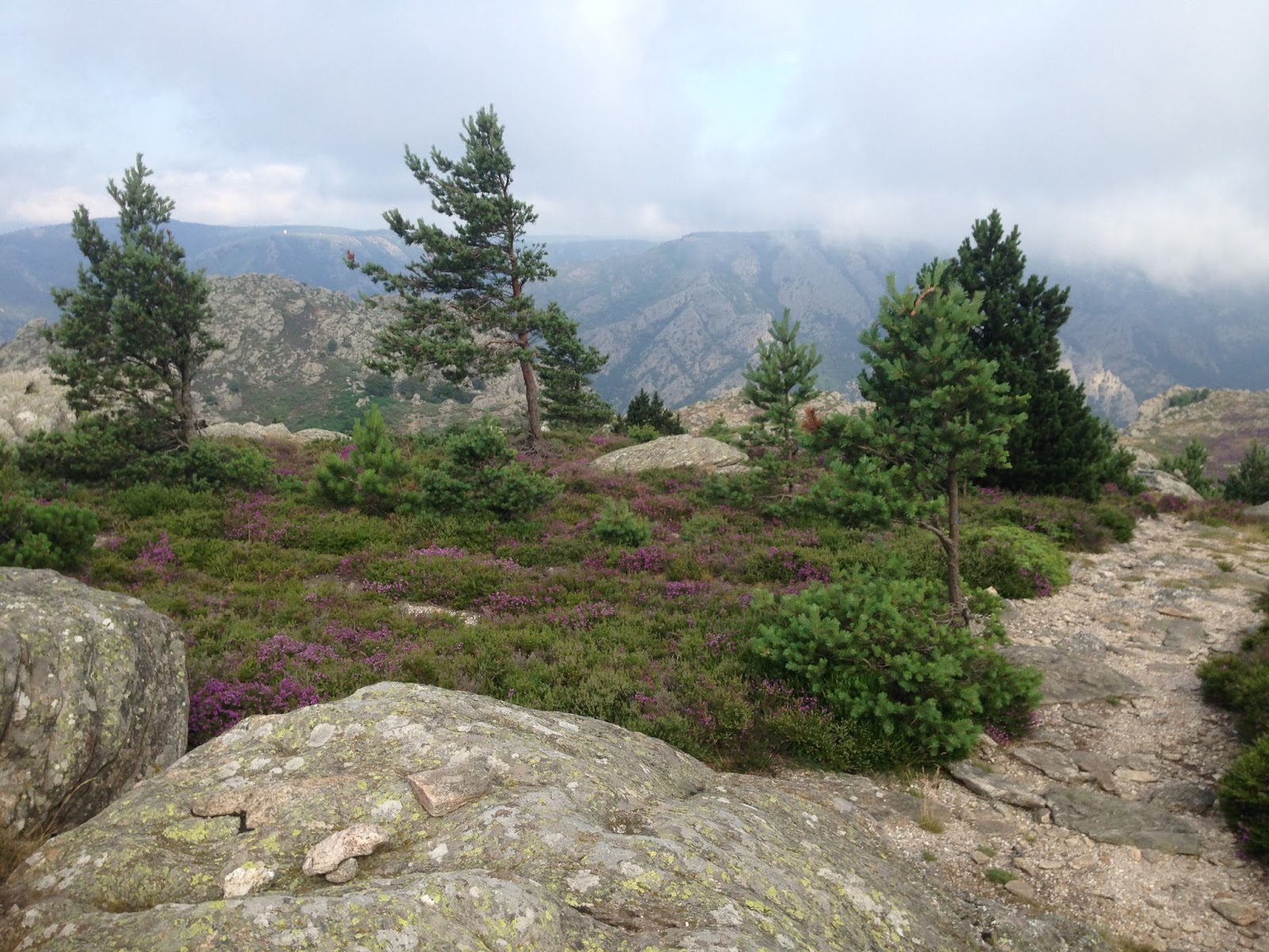
The views begin to get spectacular, even if it is a bit misty.

The trails are colour coded, sometimes switching from one colour to another. A sharp eye is required to follow the trail, rocks with dashes of paint can be easy to miss. I start on yellow then somehow get onto red, the deciding factor was red seemed to be going up more than yellow. I really should have a trail map.


Some spectacular views and a serious looking Deer Runner.

Now here is where the "run" goes a bit belly up. Instead of making my way to the easier descent at the rear of the mountain I follow a faint blue trail to the left, it seems to be heading back down the Gorge. The markings are old and hard to find, I begin to wonder if I'm doing the right thing.

The trail heads into a gully. I pack all hand held items into my back pack, I need to scramble down this descent. The track looks old and disused. I lose the markings and decide to climb down some smooth rock to try and pick up the trail once more. It gets steeper then ahead is a sheer drop. No trail here, I have no choice but climb back up to rejoin the blue trail again. I find where I have gone wrong and continue going down, the markings improve which gives me confidence during the descent.
The trail is steep where I have to slide down and cling onto trees and boulders but someone has marked this trail out so surely it's safe enough I convince myself. The trail crosses a stream, I'm in the gully with steep mountain sides, it amazes me how these trails have been made in such terrain. Blue suddenly stops, it join's a red trail, the red markings are very faint and the trail is horizontal. I don't know whether to go left or right, which side is going up or down. I take stock and decide right, it seems to be heading down more than the trail heading left. I scramble down and reach parts where some rock climbing is required, this is where a reality check is done. This is too dangerous to carry on, I have not met another hiker or hill walker on the mountain. My family know I'm on the Caroux range but not where. I have no choice but to retrace my way back up the mountain in the blazing heat. It's exhausting but must be a good workout.

I stop at the stream to cool off and fill water bottles. I notice a face in the mountainside and take the picture above before heading back up. Once back on the plateau I follow more established paths for the descent to Douche at the back of the mountain. From Douche I head on the GR7 European long distance path towards Heric.


The path is not in great shape but the scenery is absolutely stunning before I cross the bridge and arrive at Heric.


I'm hot, dusty and thirsty, a dip in the pool is in order to cool down before having something to eat and drink.
The water is crystal clear, being so far up the Gorge means only a few walkers pass by.

I dry off running gear while having a snack in the sun, pure bliss but my run is not over.
I have a very hot journey over the hills to complete yet.


The Gorge is as beautiful as ever, even with lots of tourists further down. It's getting really hot now, I stop at the car park cafe and order two cans of ice cold coke. I down one before packing the second and make my way into the hills. I have half a litre of water and the coke which turns out not to be enough.

I cross the river Jaur and make my way through Ornac before joining the road to the hills. It's well over 30 degrees. There is no shade on the exposed hillside, no respite from the sun. I begin to overheat and once again begin to wonder if I have done the right thing, but this is my choice and being stubborn means plans have to be adhered to. Eventually I find shade under a tree and down the second can of coke in one go.
The gassy coke makes me feel queezy but I push on and make my way up in the baking heat.

Fenouillede, a deserted hillside hamlet in a beautiful location. Usually I would have a walk around but I'm feeling ropey in the heat and continue up. I have finished the half litre of water and begin to get desperate.
Next remote hamlet is Courbou where I will need to ask for water. A bit further on I can hear the gurgling of a stream, not a fast flowing one but water all the same. I grab a canteen and clear the undergrowth to gain access. I place the container under a trickle, it takes an age to fill up before I can slake my thirst. I fill it a second time then pour the contents over my head, pure bliss. A third fill sees me on my way but I still struggle in the heat.


Courbou, an amazing remote hamlet has its own hillside swimming pool with a view. I resist the urge to jump in and cool off, I don't think the locals would be too happy finding a hot and sweaty ultra runner in their pool.
Courbou is deserted when I pass through, all the shutters are closed and I'm not sure if anyone is here.
I'm now on a stony track making my way to the ridge where I can drop down into the Orb valley once more.

Over the ridge and the familiar sight of Vieussan. Half an hour in the heat and I'll be done, mostly downhill which helps. Through vineyards and rocky trails I return to Boissezon, my starting point eight hours earlier.
This "run" to the Caroux took an unexpected turn, more a scramble and climb than training run. Next time I need to stick to the more established trails or take a map, but I will be back for more Caroux running in this stunning area.
Caroux run Fri 38.5 kilometers.